


Horseytalk.net/Hoofbeat EXCLUSIVE
RIDER RIGHTS

Shipwrights Way Still in choppy waters
Says Cath Hart, Shipwrights Way Project Officer, Hampshire County Council
You will be pleased to hear that the Forestry Commission have responded very positively to your requests regarding both Hardings Ride and off-road access onto Shipwrights Way at Alice Holt.
Hardings Ride (Binsted BOAT 60): This route is crossed by the tarmac drive into one of the main car parks and then by the pedestrian/cyclist access from that car park to the cafe/loos etc, both of which obviously get busy. The Forestry Commission had responded to previous requests by significantly opening up sight lines at these points and by fencing the adjacent picnic/play area so that children did not emerge suddenly onto the route. In the coming months they will also put in measures to slow 'traffic' on both of these routes. On the tarmac drive, speed bumps will be installed, the 'Slow down - path crossing ahead' signage will be replaced by bigger signs sited further from the junction, and a coloured surface dressing will indicate the crossing point itself. On the pedestrian/cyclist access track, new barriers will be installed to slow people down, along with signage. Lastly, the surfaced section of Hardings Ride will be repaired in the autumn, when the air and ground conditions are sufficiently wet for the new material to lay and bind properly.
Abbotts Wood car park: In response to requests for a traffic-free route onto the Shipwrights Way from this de-boxing car park, the Forestry Commission have very generously agreed that riders may, free of charge, use the track departing from the car park entrance to access the Shipwrghts Way - see the attached map for details.
Says Maureen Comber
Firstly, thank you for your efforts in trying to put right the problems which we identified before the trail was opened. It is a pity that the FC did not take more notice of you in the first place, but you are not the first HCC officer to have problems in dealing with them.
You do not say who was responsible for laying that unsuitable surface. Who was it? From memory the path just needed the ruts rolling out of it and some indentations filling, particularly the pond just before the main forest track in the middle which I have been highlighting as needing attention for many years. Why was it considered necessary to completely change the surface of the whole section? Was the nature of the surface ever discussed with BHS Access Officers other than myself who was not consulted?
Hardings Ride
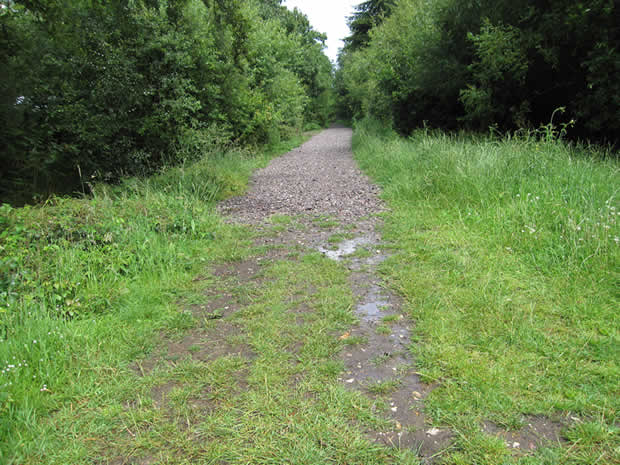
It cannot be right to deprive the public of their use of the Shipwrights Way along Hardings Ride over the summer months, particularly when the insistence was that the first section was opened so prematurely. This was contrary to my warnings that it was not yet ready and the route not properly or sufficiently thought through. In view of this may I suggest that the flints are removed or pushed to one side until such time as consultation with stakeholders with regard to a more sympathetic surface has come about. There is no need for this obstruction to remain during the summer months, further depriving public access. This reminds me that these concerns were raised by me in my last email to you on 21st April 2011 to which I have not had a reply? Perhaps closer liason with me as both Ward Councillor at that time and BHS Access Officer would have prevented these deficiencies in the route. It is a pity you decided to ignore them.
Quickly glancing at the map you showed me at the LAF visit last week I mistakenly thought that the suggested route was on the other side of the road joining the gravel track through the forest. The problem with the route now identified is that it has a very poor surface and is not maintained. We used to have a track across the top of the fields shown on your map, which then ran along the old road alignment - obvious because of the lovely old beech trees to either side and shown on the Binsted Inclosure Award; probably a suitable candidate for the PATTH Project - but this has been allowed to overgrow and typically any trail that gets overgrown or out of repair is removed from the permit, or in this case will become unusable. I therefore cannot with any confidence accept that the proposed section of the route is feasible.
It would make far more sense if the route we all used to use which runs on the south side of the road adjacent to the horse box park, to the beginning of Hardings Ride, was used instead. Some years ago now this was 'improved' by the FC with builders waste from a nearby sawmills, but was found to be contaminated and has consequently been closed ever since. I think now is the time for them to correct that error as it leads directly to the start rather than a mile further along the route.
As the BHS District Access Officer for East Hampshire which includes Broxhead Common, I would like you to please keep in close touch with any proposals for surfacing there. The BHS took Counsels opinion some year ago and were advised that the surface of a bridleway should be primarily suited to horse riders. As both turf and sand are the best types of surfacing for horse riders I would not expect a change to be made to the surface of the bridleways on Broxhead Common. I hope you will confirm that there is no intention to interfere with these bridleways which run over our rare and valuable heathlands?
I should also comment that neither BW4 or BW46 across Broxhead Common are of a suitable width for multi-user in the sense of a national trail. The narrowness would incur some health and safety concerns between various types of user. However as I think I mentioned to you, I have a claim for a restricted byway of some 30' width, declared for public use under the Finance Act 1910 which might help.
Otherwise we could look again at the route to the east of the A325 which would take in the shop, post office and pub in Kingsley and pass very close to the site of the old station in Bordon. This would seem to fulfill the commercial aims of the route far better than leading unsuspecting tourists to the dangerous bends at the end of Cradle Lane by Headley Park and then over an SSSI.